Patreon LogoYour support makes Blue Moon possible (Patreon)

[WB] GMs, what are your favourite map resources?

Shiver

Slaver Bait
Joined
Apr 26, 2019
Hi folks!

In about 2/3s of my roleplays, I take on the GM role, and I almost exclusively use original settings that I dream up. I like to put lots of effort into worldbuilding and detail for the players, and one of my favourite ways is by making maps!

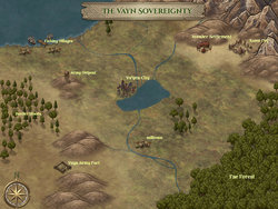
There are lots of dungeon and even city generators out there, but what's your go-to resource for making maps on a larger scale? A region, or even a continent? I've had good results with this one. It's a little tedious, but by putting in some time and polishing with Photoshop, I've had some half decent results (see example below).

How about you? What map-making or other visual resources do you swear by?

Vayn.png
 
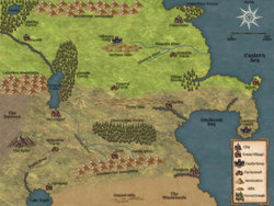
I used Inkarnate map maker. It is an online maker though as well with free and pay use options. I think yearly fee was 25$ while month was 5$ if you want to unlock all features. Though even without spending money, you can still make decent maps on it in design. You just won't have access to the majority of landscape options or even color textures for the map making. Plus they do general updates and add more stuff over time. If you really do a lot of map making, it may be somewhat worth the investment. You could also google Inkarnate and see various designs. Also you pretty much have to mouse sculpt landmass yourself, there is no auto creation of map. Maybe you can use other programs to make an auto map and then import to color it there? I never tested that. I believe there is import option.

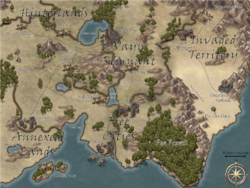
Also something I made after working off and on with the online Inkarnate maker. Which with the shading I used mainly as 'territory,' theme. Probably not best of works compared to other Inkarnate images you can find on web.
 
I think that's great! Did you do any Photoshop, or was that just using the online tool? And do you use the free version or the paid?

Thanks for sharing :)
 
I didn't know that was a thing, I always grab a big piece of poster board and hand draw my maps, leaving them empty on the inside and fill them in as players discover things or if they have a good idea I let them place locations on the map too.
 
Looks like Tazreale used the pay-to-use features of Inkarnate.

I made this using only the free options:
 
I think that's great! Did you do any Photoshop, or was that just using the online tool? And do you use the free version or the paid?

Thanks for sharing :)

Used the paid version, again free to use has a good variety as well, but paid like doubles/triples resource options. Again, depends how much you want to use it or how often. I dd paid for bout a year and haven't resubscribe simply because I do not make many maps. If I was more map heavy making, I would likely keep using it.

Also didn't use any photoshop, all that was built in options.

Basically saying if you make a lot of maps it is worth the investment for paid version. Whether it be for D&D groups or RP projects.

If it is just something you want to play around with from time to time or not invest much in, probably free version is better.
 
Used the paid version, again free to use has a good variety as well, but paid like doubles/triples resource options. Again, depends how much you want to use it or how often. I dd paid for bout a year and haven't resubscribe simply because I do not make many maps. If I was more map heavy making, I would likely keep using it.

Okay I honestly feel silly for having never found this before. Even the free version is way better than what I usually use, it's great!
 
Okay I honestly feel silly for having never found this before. Even the free version is way better than what I usually use, it's great!

Well I wasn't really too familiar with it awhile back. The only reason I found it was youtubing map making programs and one of suggestions was Inkarnate. I never stumble upon it in past with google 'Map making programs.'
 
Well I wasn't really too familiar with it awhile back. The only reason I found it was youtubing map making programs and one of suggestions was Inkarnate. I never stumble upon it in past with google 'Map making programs.'

I've been able to markedly improve my map :D
 
I've been able to markedly improve my map :D

Yea, looks great.

Also, I think there is a zoom option while making the map. The maps generally come out large when you save them or larger depending on version used in dimensional sizes automatically. I think on the Continental scale of what I did when making mine was zoom to certain areas around %150(or maybe higher, can't remember max zoom in. Since I played around before with the zoom in and save/download of map file then upload to see proportions of images.) Though I mainly used zoom and image scaling to lower percentages than their default, with some of them all the way down to 0(certain terrain) while a lot of others I think I scaled down to like 20 or so percent(trees, buildings, etc.) I know they may look tiny if you are not zoom in, but again the map comes out saved as you can see much larger in size than it shows in the maker. So objects on it will be bigger as well. Including font and all that. (Which I also scaled font down.) (Unless free has different scaling when making/working on it., if any scaling options for landscapes and whatnot? The end results both look like they come out at a 2048 + 1536 dimensional, scale size with finished project. So that could be something to always bare in mind if you want to make more use of terrain/areas.)
 
Bumping this thread to show off my vastly improved map... I've been continuing to practice. Inkarnate is great.

 
Any tips on where to build a modern city map? Like a big city.

My suggestion, start by determining the general layout of the area around the city. Typically the most important feature will be the water source of the city. Most cities always build up around some sort of water source. Most but not all. And if not around a water source they build up along a natural trade path. Once you determine that, determine about where the center of the city will be, typically near that water source but not directly on it. This will be the most developed area.
Then move on by determining the type of ground your city is lying on and if it changes at all depending on where you go. Skyscrapers tend to be built on harder denser ground areas while smaller buildings can be built elsewhere.
From there keep in mind Cities tend to grow organically, so start by planning the oldest roads, which will travel though the center of the city and then the natural travel paths. From there build out in rough patterns. Domestic Neighborhoods will tend to be a bit more grid like while main streets will develop and grow out in more random turns and curves to follow the landscape.

Just a couple initial thoughts. Then you'll have to keep in mind that Fire Stations and hospitals tend to be established based on coverage area, and police stations will tend to be built in centralized areas that they can access roads leading to a lot of parts of the city from.

As for where (like an app or something), no idea, but you should be able to use the same sorts of resources as any other type of city. You just need to adapt and maybe add some custom icons.


Though going to the base topic. I tend to use this tool to start creating my world maps:
Then I edit, clean up, and combine and cut to customize it.
 
My suggestion, start by determining the general layout of the area around the city. Typically the most important feature will be the water source of the city. Most cities always build up around some sort of water source. Most but not all. And if not around a water source they build up along a natural trade path. Once you determine that, determine about where the center of the city will be, typically near that water source but not directly on it. This will be the most developed area.
Then move on by determining the type of ground your city is lying on and if it changes at all depending on where you go. Skyscrapers tend to be built on harder denser ground areas while smaller buildings can be built elsewhere.
From there keep in mind Cities tend to grow organically, so start by planning the oldest roads, which will travel though the center of the city and then the natural travel paths. From there build out in rough patterns. Domestic Neighborhoods will tend to be a bit more grid like while main streets will develop and grow out in more random turns and curves to follow the landscape.

Just a couple initial thoughts. Then you'll have to keep in mind that Fire Stations and hospitals tend to be established based on coverage area, and police stations will tend to be built in centralized areas that they can access roads leading to a lot of parts of the city from.

As for where (like an app or something), no idea, but you should be able to use the same sorts of resources as any other type of city. You just need to adapt and maybe add some custom icons.

The map is intended to be used for my world-building Naked City concept, which is basically a large city on an island between two rivers and the ocean.
 
The map is intended to be used for my world-building Naked City concept, which is basically a large city on an island between two rivers and the ocean.

Oh that's a pretty easy setup. Like I said first generate your base map. Usually a flat featureless map is good if you want to generate a citymap. The tool I linked (edited in to be fair if you didn't see it), can be used to help generate a map with organic river and island lines. But really, any decent map making tool can be used till you get the landform you want, either by drawing it out or
But typically most islands like this will either be completely isolated or have at least two bridges connecting them to the mainland.
  • In the isolated case your entry way will be the port and will typically have a more urban section with a road leading directly out from it with warehouse and supporting facilities flanking either side of that main road. So you'll end up with a sort of "T" shape for the base of your map, with the top of the "T" being the port and warehouses and the like with a major road running along it, and the stem representing the mainstreet with most of your more developed buildings. Most main roads will be built out from the top of that "T"
  • In the case of the bridges connecting it to the mainland, the bridges will typically be built on the points closest to the shores of both sides, and then a road will develop along the path of least resistance between the two. For the most part bridges will come in pairs, one on each side of the island, not universally but generally and will be connected in pairs. There will typically be connecting roads between those bridge roads forming a basic grid that way. The City Center (or Centers depending on the layout of the island) will likely be along the path of those main roads, typically towards the middle of them unless there is some factor that draws it to some other part of the road. Such as a city closer to one side or the other, a natural port existing on the island, or large expanses of flat land to make growing a city center easy.
From there you just add in buildings along those roads. Keeping in mind that for the most part you won't have any isolated buildings from roads.
 
I made maps from scratch myself, using a number of premade assets I made. Program I usually use is Gimp II, as its free and still has a looot of options.
 
There are so many pre-made maps I've yet to run out for a space exploration game - I spend a _lot_ more time in Photoshop, HeroMaker and Roll20 modifying ships, components etc - and not just to un-PG such material, although I am quite proud of my operating technomagic fluid system... I'll be prouder if I can animate it and have the craft shut down if it's run out of juice... I'm still fighting organisation like madness there though.

For interstellar stuff, Space Balls is my go to 'mapping' mod - I've got bits from most of them, but it _does the job_ and even - with a little combination work - enable easy non-automated automatic orbits (less load, just keep track of how many orbit turns it's been, run through that number, eh viola).
 
Hi folks!

In about 2/3s of my roleplays, I take on the GM role, and I almost exclusively use original settings that I dream up. I like to put lots of effort into worldbuilding and detail for the players, and one of my favourite ways is by making maps!

There are lots of dungeon and even city generators out there, but what's your go-to resource for making maps on a larger scale? A region, or even a continent? I've had good results with this one. It's a little tedious, but by putting in some time and polishing with Photoshop, I've had some half decent results (see example below).

How about you? What map-making or other visual resources do you swear by?

Vayn.png


Wow, you're making maps? I'm not really there. I just use reddit and google with 'DnD 5e Map' in the search bar beside whatever I'm looking at. There are a TON of subreddits dedicated to this, I usually find what I'm looking for with a search in there.
 
Wow, you're making maps? I'm not really there. I just use reddit and google with 'DnD 5e Map' in the search bar beside whatever I'm looking at. There are a TON of subreddits dedicated to this, I usually find what I'm looking for with a search in there.
I like worldbuilding, so the maps are fun for me even though I don't have much in the way of artistic talent. I tend to google/repurpose maps for smaller things - caves, dungeons, cities, etc. - but I like trying to make my own world or region maps.
 
Wow, you're making maps? I'm not really there. I just use reddit and google with 'DnD 5e Map' in the search bar beside whatever I'm looking at. There are a TON of subreddits dedicated to this, I usually find what I'm looking for with a search in there.
When I'm world-building, I want the world to look my way; I don't want to have to fit my world into someone else's ideas.

As Shiver said - for cities, buildings, towns, etc... I may use existing maps made by others, but the world...? That's mine. :)
 
Back
Top Bottom